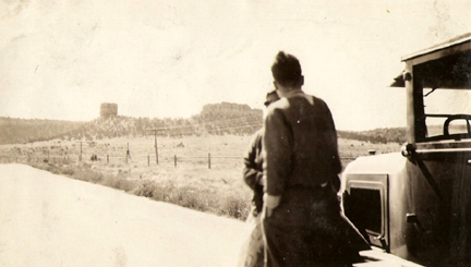
Today, I received this email from Lt. John Bayer of the U.S. Navy:
I’m seeking help identifying where the attached family photo was taken. This was photographed during a family road trip from Cleveland to CA in 1929. Presumed to be along Route 66.
The people in the photo are identified as Bayer’s uncle and great-grandmother. The year the photo was taken, Route 66 would have been only three years old.
Judging by the landscape, I’m betting it’s in Arizona — perhaps near the Grand Canyon or the Two Guns area. If anyone else has a better idea, don’t hesitate to comment.
There’s a chance this is on the Santa Fe Loop. That is, south of Sante Fe and heading south into ABQ from the north. Thios would of been before Rt 66 was realigned to cut Sante Fe off the Route. Just a thought……
A couple of clues that might help: it is more likely that this photo was taken facing west or south due to the direction of sunlight. That woukd mean that the hills would be on the north side of the road. I’m thinking that would leave out Two Guns since its on the south side. AZ or NM would be my guess. TX is too flat for this photo
Depends on where in California they were going. I could see this being on old US-466 between Barstow and Bakersfield.
Sure seems like I’ve seen this area in a photo before from New Mexico, but from the other side of structures if I remember?
Thanks everyone for giving me places to zero in on!
John B
Two possibilities come to mind. One is Wagon Mound in NE New Mexico, along the old Santa Fe Trail/National Old Trails Road. The other thought is Shiprock in NW New Mexico along the former US666. If they’re facing south when the picture was taken, each of those possibilities would be in the correct position based on where the road was/is. The uncertainty is the formation on the left side. I wonder if that could be a manmade tower.
Hard to tell in the pic here, but the formation on the left side is definitely not man-made.
Thanks,
John B