Frank Gifford, proprietor of the rt66pix.com photo site, has found an apparent error in several current editions of Rand McNally road atlases that could affect travelers in the tri-state region of Kansas, Oklahoma, and Missouri.
Rand McNally announced in 2010 it would include markings of Route 66 in its 2011 road atlases. For that, the mapmaker should be commended.
However, Rand McNally would do well to make sure its markings of the Mother Road are accurate.
Gifford wrote in his blog:
The error stretches across 60 miles of Oklahoma and Missouri, and deletes the Kansas section entirely.
The mistake appears on Missouri maps in the 2012 “Road Atlas Large Scale,” “Road Atlas Deluxe Midsize” and “Road Atlas Midsize.” The Rand McNally Road Atlas is billed as the “best-selling” in the US, and is available at travel centers and Walmart.
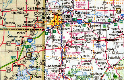
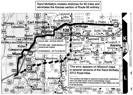
Rand McNally incorrectly shows Route 66 following US 60 northeast from Afton, OK toward Neosho, MO, then implies it follows US 71 north to Carthage, MO.
Gifford emailed me an excerpt of one page of one of those atlases that shows the apparent error:

He also created this illustration to better show the mistake (in the broken line) and the correct Route 66 alignment (in the black line):

Gifford wrote:
The actual routing from Afton is to Miami and Commerce, OK, Baxter Springs and Galena, KS, then Joplin and Carthage, MO. Route 66 has never followed the path Rand McNally shows, and the divergence is up to 25 miles.
Oklahoma and Kansas maps do not repeat this error, but in northeast OK, Route 66 is unmarked for 50 miles and cannot be followed.
Perhaps Rand McNally didn’t intend to imply U.S. 71 being Route 66. But there is no shred of doubt that the Route 66 shield on the map east of Fairland, Okla., is in error. Fairland, and the highway running east of it, never was a part of Route 66.
Gifford said he first contacted Rand McNally by email twice in February and by regular mail to its Consumer Affairs office in early March about the mistake.
To date, he said he has received no response.
UPDATE 3/21/2012: Jennifer Cavallo, director of retail sales at Rand McNally, posted a response in the story’s comments section. The gist: Rand McNally has acknowledged the error, and it will be corrected on future reprints of its atlases. It also says it will apologize to Gifford for not replying to his queries.
This stresses me greatly. You’d be amazed how many travelers who stop at Afton Station are using the Rand McNally atlas. In the first place, I don’t think it’s a great idea to use something so lacking in detail. But with this error, some of the best stops on the road are bypassed. Yikes!
That is a major error. In the past, various mapmakers have deliberately introduced small errors into their maps to tell if someone was copying them. If the same error showed up in another map, they would be highly suspicious. One such case was a “town” near where I grew up that was on a map once. It never existed.
However, this is just too big of an error. They should rectify it.
A correction to a publication as well known (and trusted!?!!) as this will be a nightmare and nearly impossible for Rand McNally to do except by recalling tens of thousands of atlases that have been shipped to wholesale vendors, who have no doubt have already sent thousands to book retailers. Even with their reputation as reliable cartographers on the line I wouldn’t be surprised if the economics involved wouldn’t lead to the decision to let this slide until the next printing–that is, if anyone in power at Rand McNally even knows about these mistakes yet. Without a response to Mr. Gifford’s attempts to contact Rand McNally there’s no way of knowing if they have been read. How frustrating. Ron, would you be willing to call Rand McNally and run the switchboard relay until you get someone on the line in the position to assure you that the errors have been noted and that what can be done will be done? I’d be willing to make the call, but your credentials trump mine. They’d see me as a nitpicking school librarian whereas they would recognize you as the Route 66 expert you are.
I suspect Rand McNally is in the “ignore it, maybe it’ll go away” mode.
I don’t have time to play phone tag with the company, but I’ll shoot them an email.
Frank found the error, and I wanted to see what sort of response he would get before publishing my article. Rand McNally had several weeks to respond to him, but did not.
Youd be surprised how effective simply posting here @ Route66News.com can be. A few years ago, I complained about Google’s lack of oversight and how for years, they’d been mistakenly listing Interstate 10 in L.A. as “Historic Route 66.” Within a week, it was mysteriously corrected over to Santa Monica Blvd. on Google Maps, albeit mistakenly all the way down to the intersection of Santa Monica Blvd. and Ocean Ave. instead of its actual terminus (turning from Santa Monica Blvd. at Lincoln and driving over to the intersection of Lincoln and Olympic.) However, with this post, perhaps that’ll change too. My hope is that someone at Rand McNally would have their web filters on to pick up the words “Rand McNally” when they’re discussed. If they do, and they sense a building chorus of detractors from the inaccuracy of their product with this post, 2013 may see a needed change in their maps. What amazes me is that after all these years, and with so many people around the world trusting in the Route 66 “EZ Guide,” and the “Here It Is!” map series, none of these map makers do their homework or have the wisdom to contact Jerry McClanahan or Jim Ross for their insights or expertise. Simply unbelievable.
Yes, Dan, we have our “web filters on” here at Rand McNally, and we’ve heard you loud and clear!
In fact, we had captured this information in February when Frank contacted us, but we did not close the loop with him to confirm that, and we apologize.
As noted above, the mistakenly placed shield appears on the non-subject part of Oklahoma on the Missouri map. The route is shown correctly on the Kansas and Oklahoma maps.
The map in question has been updated, and the change will appear in future reprints of our U.S. road atlases.
In the future, we will have a special online area where everyone can reach our Cartography/GIS team directly: randmcnally.com/tellrand will route feedback like this for immediate investigation and response.
Thanks to Route 66 News for your post on this matter!
Bravo, Frank and Ron. The old adage about squeaky wheels being the ones that get oiled seems so very appropriate when applied to an issue concerning Route 66.
Thank you Jennifer Cavallo at Rand McNally! Even small omissions like the omission of the 13.2 mile stretch in Kansas can be catastrophic to the economy of Route 66. Historic businesses through that stretch, that would have been bypassed by the majority of map readers (who will likely be using a Rand McNally map) and would have been misled by misinformation, will now be extremely grateful for your help in promoting this Historic Highway. Keeping it alive for the next generation is incumbent on all of us as Americans to promote the goodness of the USA to guests from around the world. Thank you for joining in our effort! We appreciate it.
Another thing that I would love to see addressed is for Rand McNally to include the Route on their urban “inset” maps. I have written them a couple of times about this but have reecieved no responses.