I’m no cycling aficionado, but I’ll confidently say the Bicycle Route 66 map series from the nonprofit Adventure Cycling Association will be absolutely indispensable for any cyclist considering travel on the Mother Road.
The maps aren’t just a bunch of GPS waypoints slapped on paper. They show two years of research and field work by the association, and are chock-full of useful information and well-considered inclusions even non-cyclists will appreciate.
I took a lot of notes while examining the maps:
— The six-map set is printed on No. 2 plastic paper that won’t tear. Each map is as follows: Chicago to St. Louis; St. Louis to Joplin, Missouri; Joplin to Adrian, Texas; Adrian to Gallup, New Mexico; Gallup to Oatman, Arizona; and Oatman to Santa Monica, California.
— Bicycle Route 66 is 2,493 miles, about 50 miles longer than the original path of Route 66. The path doesn’t strictly follow Route 66 from Chicago to Los Angeles, but “as much as practical.” Purists may quibble with parts of the bicycle route, but one of the aims is to get participants to their destination, not risk life and limb in crowded urban areas.
— With that in mind, the Adventure Cycling Association’s path doesn’t follow Route 66 in Chicago or several outlying areas because of “high traffic levels and safety concerns.” Instead, it follows a chain of bicycle paths with the Lakefront Trail, Burnham Greenway Trail and the Old Plank Road Trail to Joliet, Illinois.
— Other bicycle path detours that get away from high traffic include the Constitution Trail in Bloomington, Illinois; Interurban Bike Trail in Springfield, Illinois; Riverfront Trail in St. Louis; and the Glen Helen Parkway and Pacific Electric Bike Trail in the Los Angeles region. A few other bike trails I didn’t mention are short or parallel to Route 66.
— The path contains a number of notable detours, including to Highway P through Newburg, Missouri (which may have been very early Route 66); through the western Missouri towns of Miller and Round Grove; Turquoise Trail from Santa Fe to the eastern Albuquerque; side streets instead of much of Central Avenue in Albuquerque; a side trip to Sky City, New Mexico; a side trip to El Malpais National Monument; an alternate route on Territorial Road to Winslow, Arizona; and side streets through Beverly Hills (on Carmelita Avenue) and Santa Monica (on Broadway) in California.
— Some cycling on interstates will become necessary, but not until west of Alanreed, Texas, because of unavoidable interstate.
— Bicycle Route 66’s path takes the early Santa Fe alignment, but avoids the 1926-32 alignment from Springfield to Staunton, Illinois. It also takes the early Highway 100 alignment through the St. Louis metro area.
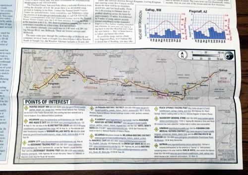
— Each map contains a Points of Interest summary map. It isn’t all-inclusive because of space limitations, but the association seemed to do well in finding high points in each region.
— Each map comes with summary of an area’s riding conditions, etiquette, cycling rules (including on Native American land), and climate. Bar graphs show average monthly precipitation and temperatures.
— The maps include markings for restaurants, grocery stores, convenience stores, bicycle shops, libraries (for Internet service), post offices, campgrounds, motels, bed-and-breakfasts and hostels. The maps also contain service directories for the above in each substantial town, including phone numbers and addresses.
— Each map comes with Field Notes about the history of the region and how Route 66 came to be.
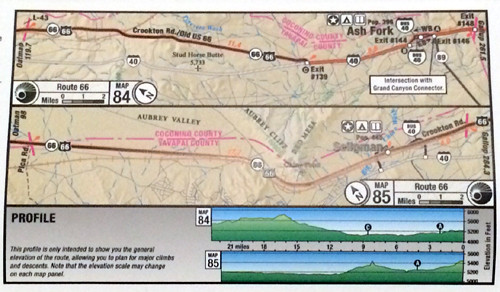
— Map excerpts generally come in 30-mile increments that are well-marked and easy to understand. Kudos to the Adventure Bicycle Association cartographer; this sort of work is harder than it looks. And each excerpt comes with turn-by-turn directions.
— Each map excerpt provides elevation summaries detailed enough to show specific overpasses or underpasses along the route.
— A few of the maps come with an enclosed addendum to tell travelers of changed road conditions, such as the closure of Route 66 from Essex to Amboy in California, that occurred after the maps were printed. (Addenda also can be found here.) Teri Maloughney, director of sales and marketing for the association, says updated editions of the maps will be out in spring or summer 2016.
— The Adventure Cycling Association recently offered the maps in digital form here. The whole map set is available, as are separate maps. Digital maps come in GPX Exchange Format. The association says the digital files are “a companion form” to the map series.
If you haven’t already guessed, this map set will be essential for any cyclist who wants to travel Route 66. I wouldn’t be surprised if it inspires a mini-boom of cycling tourism in the coming years.
Highly recommended.


I’m sorry, but having looked over the Illinois map, I have to say I’m shocked and annoyed: they COMPLETELY *avoided* the route in a really obnoxious way between Jackson & Michigan in downtown Chicago and downtown Joliet. There are *much* better alternatives that going 33 miles out of your way to Lansing!!! That was just stupid. I’d encourage cyclists to use a different Route 66 bike map created by Illinois bicyclists; that one still doesn’t hew to route 66 as much as I’d like south of Joliet, but it comes a LOT closer to the route in metro Chicago than this one does. If you use ACA’s map, you see **nothing** of Route 66 in the place where it began. That’s just stupid and needlessly insulting.
Don’t count it. Having just finished riding 66 from Santa Monica to Kingman Az I can attest that I’ve ridden across some of the worst roads in my over 25 years of cycling, particularly from the 160 Miles from Barstow to the one gas station town of Fenner. Then after riding 25 miles through A part of road closed for re-tarring (had to get permission to ride on this section from county road crew supervisor) had to ride 6 miles on Hwy 95 – no shoulder so had to ride on fwy.
Then after 10 mile interstate 40 ride into Needles I was welcomed by a couple miles of torn up 66 right through town.
In summary, much of 66 is poorly maintained if at all. From Ludlow to Amboy had to zigzag from eastbound to westbound lane to try to avoid numerous potholes and road bumps. Amboy to Hwy 40 approach to Needles is basically a rundown 100 mile ghost town . I would not recommend this part of 66 to any cyclists.
So far riding east into Arizona has had spectacular views but lot of street surface still bumpy. I’m already exploring alternative routes.